I have always want to see Stonehenge, which is located about 8 miles north of Salisbury, which is about 90 miles southwest of London. I finally got the opportunity to go there on June 7th. Prior to visiting Stonehenge, I spend a couple a days in Salisbury visiting other historical sites.
Salisbury City Hall.
In the fore ground is a monument dedicated to the men and women of Salisbury, who gave their lives during World War I & II.
The Poultry Cross.
Originally there were four crosses built during the early 13th
century. There were crosses for poultry,
livestock, cheese and milk, and wool and yarn. They served as a shelter for
the people shopping in the market.
Today, only the Poultry Cross remains.
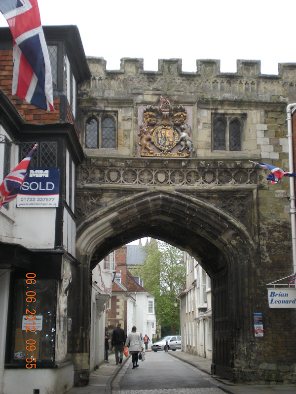
High Street Gate.
In the early 13th century, because of constant trouble between the clergy and the citizens of Salisbury, King Edward III allowed the church to build a wall around the area where the Salisbury Cathedral was located. At one time, the gateway had a drop down door, which could be closed when the citizens were particularly rebellious.
Salisbury Cathedral (Cathedral Church of the Blessed Virgin Mary).
The first Salisbury Cathedral was built on Old
Sarum (the hill north of present day Salisbury) between 1075 and 1092. A larger church was built on the same site around 1120. However, deteriorating
relations between the clergy and the military at Old Sarum led to the decision
to re-locate the cathedral elsewhere
The building of the new cathedral was begun in
1220. The main body was completed in only 38 years and is said to be a masterpiece
of Early English architecture.
The new site for the cathedral is supposed to
have been selected by shooting an arrow from Old Sarum, although this can only
be legend as the distance is almost two miles. It is sometimes claimed the arrow hit a white deer,
which continued to run and died on the spot where the Cathedral now exists.
The cathedral contains the best preserved of
the four surviving copies of the Magna Carta and a large mechanical clock
installed in the cathedral in 1386 — the oldest surviving mechanical clock in
Britain. The spire is 404 feet
high making it the highest in England and the third highest in Europe.
The Nave - Salisbury Cathedral.
The Medieval Clock.
This clock was made around 1386 and was originally located in a separate bell tower (demolished in 1792) just to the north of the Cathedral. It is probably the oldest clock in existence. Like all clocks of that date, it has no face, but strikes the hour on a bell located in the Cathedral roof space. Notice the huge counter-weights.
It was in storage until 1956 when it was repaired and set in its current location.
St Lawrence Chapel in Salisbury Cathedral.
This picture is for all Queen Elizabeth's admirers. The altar frontal and wall hangings behind the altar were made from some of the 1,500 yards of silk that were especially produced for the wall hangings which adorned the walls in Westminster Abby for the Queens coronation on June 2, 1953.
The Cloisters at the Cathedral.
The Cloisters were completed in about 1270 and are the largest and earliest in any English cathedral.
Chapter House - Salisbury Cathedral.
This is the location of one of the four remaining copies of the Magna Carta. Two are in the British Library and the other is in Lincoln Castle.
Originally they were to make 40 copies on the document so one could be delivered to each of the 40 English Barons who forced King John to sign the document. However, for some reason, only 13 were produced.
The Magna Carta.
The Magna Carta is Latin for "Great Charter". It set down
rights which became part of English law and which are now the foundation of the
constitution of all countries which speak English. It did not grant any new
rights, but it did protect existing rights in writing. These rights included
the basic right of anyone convicted of a crime to a jury trial; protection of
private property; reasonable limits on taxes and a degree of guaranteed
religious freedom. The Magna Carta was a significant influence on the long
historical process that has resulted in the rule of constitutional law today.
The Magna Carta came about because King John (who only became king in
1199 when his brother King Richard I died) had a reputation for being
tyrannical. His reign was marred by continuous war losses, beginning with the
loss of Normandy to Philippe Auguste of France and ending with England torn by
civil war. King John risked being forced out of power because of his
mismanagement. By 1215, England's nobility was fed up with paying extra
taxation. Members of this nobility rebelled and captured London. In June, the
King met these barons at Runnymede on the Thames River to try and reach a
peaceful settlement. The King reluctantly agreed to their demands by signing
the Magna Carta on June 15, 1215. It was intended to limit the powers of the
monarch and proclaimed certain liberties for "freemen".
Many later documents such as the US Constitution were based upon the
Magna Carta.
What I found remarkable was the size of the document. It is not much larger than an 8 1/5 x 11 sheet of paper. As you can see from the picture above, it was written without any paragraph breaks. According to the museum guide, the document, written in Latin, contains 3,500 words comprising the 63 articles outlining the rights of English citizens. The document is written on parchment. What I did not know, was that parchment, is the skin from a calf. The parchment, that this document was written on, was the largest piece they could get from a calf.
I think now I can understand why only 13 copies were written. Can you imagine trying to write 40 copies?
St Ann's Gate.
This is the second of four gates, that were built into the stone wall surrounding the Cathedral area, in the early 13th century. Just like the High Street Gate, this gate too could be closed when the citizens were particularly rebellious.
In the room above the gate, with the windows, was occupied by the composer George Frideric Handel. This is where he gave his first public concert in England.
The Parish Church of St Thomas Becket.
The original church was a small wooden chapel built about 1220 to be used by the men building the Salisbury Cathedral. In 1226 a small stone church was built and dedicated to St. Thomas of Canterbury. Additional building in 1548 resulted in the current building.
The Last Judgement (The Doom Painting) - St Thomas Becket.
The Doom Painting over the Chancel Arch is the
largest in England. It was painted in around 1475 as a thank-offering for a
safely returned pilgrim. The painting was white-washed over at the Reformation
and remained forgotten until the 19th century when it was rediscovered and
restored. Christ is shown sitting before the New Jerusalem, with the good being
raised to heaven and the bad being sent down to hell. The figures on either side of the arch are
thought to be St. James (left), patron saint of pilgrims, and St. Osmund
(right), first Bishop of Salisbury.
The Nave - St Thomas Becket.
After sight-seeing in Salisbury, it was off to Stonehenge.

Diagram of how Stonehenge would appear if all of the stones were upright. The shaded rectangles, in the top picture, show the surviving stones.
The outer ring of 30 stones, of which 17 are still standing, is called "The Sarsen Circle. It is so named because the stones are composed of a type of natural sandstone called Sarsen. The circle is 108 feet in diameter. The stones are 13 feet high, 7 feet wide, 4 feet thick and weigh about 50 tons each. They were placed about 3.5 feet from each other. To connect the stones on top to each other, they used stone lintels, which were 10.5 feet long, 3.5 feet wide and 2.5 feet thick. They curved slightly inward to form the circle.
The circle inside the Sarsen Circle is called "The Bluestone Circle". It was comprised of 60 stones of which 23 are still standing. These bluestones are much smaller than the stones which make-up the Sarsen Circle. They were about 10 feet tall, 3 feet wide, 3 feet thick and weigh 4 tons each. The bluestones are a type of igneous rock, called dolerite, that is found 240 miles away in the Prescelly Mountains in Southwestern Wales. This type of dolerite appears blue when wet, and hence the nickname "bluestones."
The 10 Sarsen stones inside the Bluestone Circle, in the shape of an immense horseshoe, are called "Trilithons" which is Greek for "Three Stones." Originally, these 10 stones were set in pairs and topped by a shaped stone called a lintel. These Trilithons are 20 feet tall and weigh nearly 50 tons each. Only 4 of the original 10 are still standing.
Inside the Trilithon horseshoe is the smaller horseshoe of 19 bluestones called "The Bluestone Horseshoe". It is the same type of stone that was used for the Bluestone Circle. Only 11 are still standing
The large stone inside the Bluestone horseshoe is the Altar Stone. The Altar Stone is over 16 feet in length, almost 4 feet wide and weighs about 9 tons. It is no longer standing. While it cannot be said for sure what the true purpose of this stone was, it is generally assumed to have been used for religious and ritual purposes.
I wanted to visit the inner circle of Stonehenge and it is very difficult without a tour guide, so I booked a tour. There were 9 of us in the tour group. At 7:30pm everyone not associated with our tour group had to leave Stonehenge. We were then allowed to go into the inner circle. We had an hour, all to ourselves. During this time the guide gave us the complete history of Stonehenge. We were then free to explore Stonehenge up close.
In the past, people have chipped off parts of the stones, so now there are security guards to prevent that from happening. Also, we were not allowed to touch the stones. As you will see in some of the pictures, there is bacteria and mold growing, due to people touching the stones.
I know that some people think of Stonehenge as just a big pile of rocks. However, when you consider how the people (who ever they were) were able to build such a structure, with very primitive tools, to me it is absolutely amazing.

Stonehenge from outside the circle. When you first view Stonehenge, it looks small, part of that is due to the fact that it sits on over 2,000 acres and there are not any other structures around.
Construction of the Inner Ring
About 2,000 BC, the first stone circle
(which is now the inner circle), comprised of small bluestones, was set up, but
abandoned before completion. The stones used in that first circle are believed
to be from the Prescelly Mountains, located roughly 240 miles away, at the
southwestern tip of Wales. The bluestones weigh up to 4 tons each and about 80
stones were used, in all. Given the distance they had to travel, this presented
quite a transportation problem.
Modern theories speculate that the stones were dragged by roller and
sledge from the inland mountains to the headwaters of Milford Haven. There they
were loaded onto rafts and sailed along the south coast of Wales, ultimately
ending up at West Amesbury, leaving only a short 2 mile drag from West Amesbury
to the Stonehenge site.
Construction of the Outer Ring
The giant sarsen stones (which form the outer circle), weigh as much
as 50 tons each. To transport them from the Marlborough Downs, roughly 20 miles
to the north, is a problem of even greater magnitude than that of moving the
bluestones. Most of the way, the going is relatively easy, but at the steepest
part of the route, at Redhorn Hill, modern work studies estimate that at least
600 men would have been needed just to get each stone past this obstacle.
Once on site, a sarsen stone was prepared to accommodate stone
lintels along its top surface. It was then dragged until the end was over the
opening of the hole. Great levers were inserted under the stone and it was
raised until gravity made it slide into the hole. At this point, the stone
stood on about a 30° angle from the ground. Ropes were attached to the top and
teams of men pulled from the other side to raise it into the full upright
position. It was secured by filling the hole at its base with small, round
packing stones. At this point, the lintels were lowered into place and secured
vertically by mortice and tenon joints and horizontally by tongue and groove
joints. Stonehenge was probably finally completed around 1500 BC.
Who Built Stonehenge?
The question of who built Stonehenge
is largely unanswered, even today. The monument's construction has been
attributed to many ancient peoples throughout the years, but the most
captivating and enduring attribution has been to the Druids. This erroneous
connection was first made around 3 centuries ago by the historian John Aubery (1626-1697). Julius Caesar
and other Roman writers told of a Celtic priesthood who flourished around the
time of their first conquest (55 BC). By this time, though, the stones had been
standing for 2,000 years, and were, perhaps, already in a ruined condition.
Besides, the Druids worshipped in forest temples and had no need for stone structures.
The best guess seems to be that
the Stonehenge site was begun by the people of the late Neolithic period (around 3000 BC) and carried forward by people
from a new economy which was arising at this time. These "new"
people, called Beaker Folk because of their use of pottery drinking vessels,
began to use metal implements and to live in a more communal fashion than their
ancestors. Some think that they may have been immigrants from the continent,
but that contention is not supported by archaeological
evidence. It is likely that they were indigenous people doing the same old
things in new ways.
Why was it built?
Most archaeologists are certain that Stonehenge was constructed
as a holy place for religious rituals and ceremonies. It is very probable the
early architects were sun worshipers.
When the first rays of the rising sun align with the heel stone, at the
entrance of Stonehenge, the light shines directly into the center of the
circle.
The smaller Bluestone rocks.
When the rocks get wet, they turn a bright blue color.
A picture of the Heel Stone taken from inside Stonehenge.
The Heel Stone stands outside the entrance to the stone
circle enclosure. When the summer solstice sun rise over the Heel
Stone, the rays of the sun hits directly in the middle of the circle. In other words, it was and still is a marker stone for summer solstice (June 21st). The opposite side of Stonehenge faces the winter solstice sunset.
The Heel Stone is a rough, unfinished sarsen stone, approximately 16
feet high with another 4 feet buried below ground, 8 feet wide, 7 feet thick, and weighing some 35
tons. It now leans inwards, towards Stonehenge, but most
likely once stood upright.
The name may be derived from the Greek word for the sun - 'Helios'
or it might be that it
"heels" (leans).
If this stone was still standing, the last rays of the setting sun, during the winter solstice (Dec. 21st), would shine over it and hit directly into the center of Stonehenge.
Jim in the inner circle at Stonehenge.
The rock in the upper half of the picture is one of the lintels (the top cross piece that connects 2 of the larger stones). In the middle of the lintel, you can see where they have hollowed out part of the rock. The other end was the same way. The builders then lifted the lintels into place, thus holding the large stones together.
A close-up of 2 lintel rocks. It is amazing that the builders could shape the rocks to fit so tightly together, given their primitive tools. You can not even slip a sheet of paper between the two connecting lintels.
The image of a dagger on one of the Sarsen stones. Archaeologists have determined that the carving was made around 2000 BC. In the top half you can see some grafiti. Now there are guards on duty to prevent any addtional destruction to the stones.

Amesbury 43, Barrow.
There are over 2,100 acres surrounding
Stonehenge, all owned by the British Government. As you look around the area, where Stonehenge is located,
you will see many mounds such as the one pictured above. It is estimated that there are well
over 500 such mounds around Stonehenge and more in other parts of the UK.
It has been estimated that around 350 of these
mounds have been opened and examined.
Some of the mounds contained human bones. However, many of them just contained artifacts from the
Bronze Age.
The mound pictured above is named “Amesbury
43”. The name was taken from the town of Amesbury, which is located just north of
Stonehenge.
According to our guide, the barrow pictured
above was opened in 1722, but no record exists of what was found. Archaeologists have concluded that it
means that probably nothing significant was found.
The mound is over 200 feet in diameter and comprises a roughly circular
central mound that is over 11 feet high.
If you ever get the opportunity to visit Stonehenge, be sure to hire a guide, you will come away from your visit with a better appreciation of Stonehenge. It is NOT just a big pile of rocks.